Sea-ice
The main geophysical parameters derived from altimetry are the sea-ice freeboard, the snow depth and the sea-ice thickness. The figure below, from Quartly et al., displays a schematic illustration of these 3 parameters:
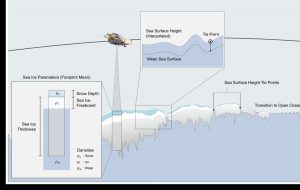
A schematic showing that an altimeter measures the distance to ice surface (or the leads within it), so sea-ice thickness calculation must allow for the weight of snow layer and the difference in densities of water and ice. Credit to Quartly et al., 2018.
Ice sheet
The main geophysical parameter derived from altimetry is the surface elevation. The surface topography derived from altimetry is helpful for many scientific applications. In particular: Digital Elevation Model (DEM) definition, mass balance monitoring (global warming related), ice shelf thickness change, subglacial lake drainage, grounding line location.
![]()
25 years of elevation changes of the Greenland Ice Sheet from ERS, Envisat, and CryoSat-2 radar altimetry. Credits Sorensen et al., 2018
Ocean
The main geophysical parameters derived from altimetry is the sea elevation. In the Polar Monitoring project a focus was given to polar ocean. Compared to open ocean, specific problems add up over sea-ice areas:
- A degradation of the altimeter range accuracy
- Radiometric estimations are contaminated by the presence of ice-floe. Subsequently wet tropospheric correction is less accurate compared to open ocean
- Concerns regarding the Dynamic Atmospheric Correction (DAC) accuracy
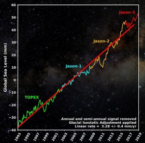
Global mean sea level evolution from 1993 to 2019 as measured by TOPEX & Jason satellites