1 – AltiDop presentation
Since the inception of radar altimetry, 25 years ago, CLS developed and continuously improved several numerical simulation tools to understand and study the altimetry measure. In this study, we use “AltiDop”, a versatile simulator, with an end-to-end capability: from scene generation to level-2 retracking. It has the capability to simulate altimetry waveforms in multiple ways:
The waveforms are simulated through a numerical pixelized-scene. Each pixel representing a facet, a portion of the scene, for which the altimetry signal backscattered is computed using the radar equation (see equation 8). The signal therefore depends on:
- Antenna/facet distance
- Antenna gain pattern
- Facet radiometric model, which describes the interaction between signal and facet, in particular the backscattering variation as function of the incident angle
- Mean square slope (itself depending on sea state over ocean)
- Facet slope
The simulator is mainly used for oceanic studies, and it is possible to generate scenes with facets elevations and slopes reproducing realistic sea states: windsea and swell conditions notably.
- In recent years, some developments have been made to generate scenes modeling simple inland waters scenarii.
- It is possible to add topographic surface slopes to the scene. Moreover, first tests have been made to integrate topography directly coming from the Reference Model Of Antarctica (REMA), a high resolution (8 meters) Digital Elevation Model.
- It is possible to directly simulate model waveforms, in power (I & Q), to avoid any speckle noise. But also to simulate complex radar pulses (I2+Q2), and successively run dedicated level-1 processing to build LRM/SAR/LR-RMC waveforms similarly as it done by ground segments algorithms.
- In this study we simulate only power model waveforms to precisely assess the waveform shapes, without any speckle noise addition
- Waveforms can be simulated along simple orbit cases (constant altitude or constant radial speed, but it is also possible to use real orbital data.
- Simulations are possible with all the current and past altimetry missions. The simulator takes into account their specific properties (altimeter instrument, antenna, orbit…) listed in a configuration file.
2 – Main operating steps
a) Scene generation
A numerical scene is generated, corresponding to a 2D data matrix, with each matrix element representing a surface facet. Facets elevation can be computed in several ways:
- A basic scenario with a complete flat scene, all facet elevations are set to 0.
- A Gaussian distribution with an amplitude controlled by a Significant Wave Height defined in the configuration file
- An “oceanic wind-sea” or “oceanic swell” or “oceanic well + wind-sea” scenario from Pierson-Moskovitz / Elfouhaily spectrum
- REMA, Reference Model Of Antarctica, an Antarctica DEM, at 8 meters spatial resolution.
- Elevations can also be set manually, by directly modifying the matrix of elevations
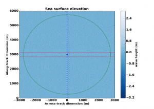
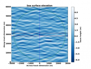
Illustrations of two oceanic scenes simulated by AltiDop. A wind-sea scenario (left) and a swell scenario (right).
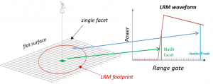
b) Radar equation computation
The altimetry signal backscattered by each facet is computed using the radar equation, formulated by Brown [1977]:

Where : Pe : Emitted power of the antenna / λ0 : Wavelength = c / Fc (with c the light speed and Fc the band frequency) / R : The satellite – ground distance / G : The antenna gain / Sigma0 : Backscatter coefficient // dS : Surface of a sea facet
c) Waveform generation
The altimeter range is computed for every facet given the antenna/facet distance. Thanks to this range distance the contribution of each facet is added at the correct altimeter waveform sample (or range gate). Waveforms can also be oversampled in the range dimension, allowing a numerical convolution with a realistic Pulse Target Response (PTR) with a sinus cardinal shape. The oversampling factor is set by the user.
The Figure below illustrates the final step of the AltiDop simulation, when the LRM power waveform (or the complex pulses) are constructed:
The AltiDop simulator has been extensively used for generating LRM/SAR data over different sea scenarii, making it a highly versatile and useful tool for investigating sea state effects on low- and high-resolution mode altimetry data. Oceanic simulations have been fully validated. Biases with the CNES simulator used in Sentinel-3A Processing Prototype level-2 [Boy et al., 2017] are extremely small (less than 1cm in range and SWH). First simulations made using high-resolution REMA topography show very good agreement with real acquisitions.