The main geophysical parameters were listed in the dedicated technical note, for each studied surface. The maturity level of each algorithm was discussed. A Scientific Readiness Level (SRL) was given to each algorithm, from 1 (initial scientific idea) to 9 (science impact qualification). Below is a table summarizing the most important/relevant algorithms:
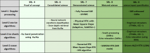
These SRL were defined using our current state-of-the-art knowledge. Therefore, for some algorithms the SRL cannot be directly transposed on Ka-band measurements, especially the SRL relative to Doppler processing: Fully Focused SAR, Low Resolution – Range Migration Correction (LR-RMC) mode, SARIn mode, SARIn swath processing. Nonetheless, in our knowledge there is no justification these processing would not work as efficiently as it does in Ku band. Except potentially for SARIn processing, which will be more sensitive to phase ambiguities over the ice margins steep surfaces.